


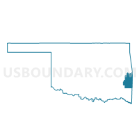
Voting District 310, Le Flore County, Oklahoma
About
Outline

Summary
| Unique Area Identifier | 654280 |
| Name | Voting District 310 |
| County | Le Flore County |
| State | Oklahoma |
| Area (square miles) | 26.04 |
| Land Area (square miles) | 25.91 |
| Water Area (square miles) | 0.13 |
| % of Land Area | 99.48 |
| % of Water Area | 0.52 |
| Latitude of the Internal Point | 34.89141880 |
| Longtitude of the Internal Point | -94.65636340 |
Maps


Graphs
Select a template below for downloading or customizing gragh for Voting District 310, Le Flore County, Oklahoma


Neighbors
Neighoring Voting District (by Name) Neighboring Voting District on the Map
- Voting District 211, Le Flore County, OK
- Voting District 212, Le Flore County, OK
- Voting District 309, Le Flore County, OK
- Voting District 311, Le Flore County, OK
- Voting District 312, Le Flore County, OK
Top 10 Neighboring County Subdivision (by Population) Neighboring County Subdivision on the Map
Top 10 Neighboring Place (by Population) Neighboring Place on the Map
Top 10 Neighboring Elementary School District (by Population) Neighboring Elementary School District on the Map
Top 10 Neighboring Unified School District (by Population) Neighboring Unified School District on the Map
- Heavener Public Schools, OK (5,107)
- Wister Public Schools, OK (2,309)
- Howe Public Schools, OK (1,813)
- LeFlore Public Schools, OK (1,689)